Sunday, January 29, 2012

OLA Backcountry Day

Pictures from OLA Backcountry Day (first ever!) up in Avalanche Bowl, Galena area. 

Tyler Davis, class of 2010 (right?) joined us for the day and we were stoked to have him!

The one and only "Ders" with part of our crew heading up behind him.

Elliot dropping in. 
If the terrain is green light, why not act silly?

Money shot.

Tuesday, January 24, 2012

Check out this avalanche video.  Some really fun skiing but also a good lesson about terrain traps and the fact that its often the little avalanches in snarky spots that get ya.


Wednesday, January 18, 2012


Saddle Peak just south of Bridger Bowl, MT
6th ANNUAL AVALANCHE AWARENESS WEEK ~ January 29-Feb 4, 2012
WHAT IS THE GOAL OF AVALANCHE AWARENESS WEEK?
• Increase community awareness of avalanches and their effect on us as mountain town residents
• Promote a safe approach to recreating in potential avalanche terrain
• Provide free avalanche education programs and clinics open to anyone
• Increase utilization and support of the Sawtooth NF Avalanche Center's services

WHAT IS HAPPENENING DURING AVALANCHE AWARENESS WEEK?

AVALANCHE AWARENESS PROGRAM
When: Tuesday, January 31st, 7-8pm
Where: Hailey Community Campus, Rm 903
What: This presentation provides an introduction to avalanches, including where and why they occur, avalanche warning signs, and the basics of avalanche safety. This program is an excellent primer before taking an avalanche class, or for anyone who is seeking information about avalanches.

AVALANCHE RESCUE BEACON CLINIC
When: Saturday, February 4th, 1-3pm
Where: Avalanche Rescue Training Park, next to Our Lady of the Snows Catholic Church on Sun Valley Road (please park in Forest Service lot)
What: SNFAC Staff will teach how to use an avalanche beacon to quickly find a buried partner. Only a couple demo beacons will be available, please bring your own beacon and probe if you have one.

FRIENDS OF THE SNFAC FUNDRAISER & BEST OF BANFF FILM FESTIVAL
When: Friday & Saturday, February 3rd & 4th doors open 6pm
Where: NexStage Theater, South Main Street, Ketchum
Tickets: Film Tickets at Backwoods, The Elephant's Perch, Chapter One and at the door. Raffle Tickets at Backwoods, The Elephant's Perch and at the films.
What: This is the 15th annual Friends fundraising event. An incredible raffle will be held each night with awesome prizes including skis, bindings, snowshoes, packs, clothing, avy gear, an overnight at a Sun Valley Trekking yurt, dinners at Galena Lodge and gift certificates to local businesses. All raffle tickets will be thrown back into the pot for the Grand Prize of a day of heli skiing with Sun Valley Heli Ski.

Please join the SNFAC in promoting the 6th Annual Avalanche Awareness Week. Together we can raise the bar for avalanche awareness in the Wood River Valley and ultimately save lives. For additional information call the Avalanche Center at 622-0095, email us, or check out www.sawtoothavalanche.com.


If you would like to be a part of the Friends activities or help donate, contact Sara Lundy, the Friends Executive Director at (208)721-1791, email
friends@sawtoothavalanche.com, or write to:

Friends of the SNFAC
PO box 2669
Ketchum, ID 83340

Level One Avalanche Course:
When:  Feb 18-20
Where:  Tournak Yurt
Who:  Conducted by Sun Valley Trekking
Cost:  $450
Included:  Food, Hut, Instruction


Level 1 Avalanche Clinic for Backcountry Skiers and Snowboarders


Course Description

This course is designed as an introduction to avalanche phenomena as it relates to backcountry skiers and snowboarders.  The course format will emphasize practical avalanche awareness and safety measures through hands-on learning.  The entire course will be based in the backcountry at one of Sun Valley Trekking’s deluxe huts.  Group food, lodging, course book, and instruction are included in trip cost.

Course Objectives
Students who complete this course should be able to:
~Identify avalanche terrain
~Identify basic snow crystal types
~ Relate how crystal type affects snowpack stability
~Identify strong and weak layers in the snowpack
~Test the snowpack to determine stability/instability
~Make basic backcountry weather forecasts
~Apply safe travel techniques
~Perform quick and efficient avalanche rescues

Course Prerequisites

This is a backcountry course that will require intermediate skiing/boarding ability and good physical fitness. No prior avalanche training is necessary, although some preliminary reading is recommended.  Contact us for a reading list and equipment list.

Course Structure:
Level 1 Courses are intensive three day clinics beginning on Saturday morning and finishing on Monday afternoon.  The entire course will be based in the backcountry and lodging will be at the Tornak backcountry ski hut at 8600’ in the Smokey Mountains, Idaho.  It is also possible to do custom courses, custom dates, based from town instead of a hut-based course.


Sun Valley Trekking


Post Office Box 1300  Hailey, Idaho Phone/fax (208) 788-1966
www.svtrek.com info@svtrek.com

Saturday, January 14, 2012

Welcome to the OLA Blog!

Welcome to the Community School OLA blog! We envision this shared space to be used to:

- Share personal, mentor, club, or school trip experiences.

- Make announcements about upcoming trips, offerings,  or events.

- Ponder important questions about leadership of people and stewardship of wild places.

- Provide a space that we can connect and call our own to check in with as our incredibly busy schedules allow.

*Our collective contributions to this space will reflect on all of us as members of the Outdoor Leadership Academy, of the Community School, and to the greater outdoor industry. All contributions to this page in any form need to comply with the Community School Acceptable Use Policy (AUP) for technology.  Please be mindful of this as you contribute.

Friday, January 13, 2012

Anders learns snow stuff


Anders F, 9th grade OLA student, soaking in the knowledge at an Intro avalanche class offered by SNFAC in early January. You see, if you hang around with local experts like Schley, the knowledge percolates into your brain and settles right in there. As long as you don't encounter any persistent weak layers in your brain (some people seem to have these year after year), the knowledge should stick around for a while.
Anyhow, here is Anders taking it all in.

Tuesday, January 10, 2012

Expedición Aconcagua
Dec 2011


  • Location:  Andes Range, Argentina
  • Highest Peak in the Americas:  22,841 feet,  6962 meters
  • Highest Peak outside Asia
  • Available oxygen at summit: 40% of sea level
  • Climber success rate:  approx 30%
  • Deaths per year:  5-7
  • Major Hazards:  Extreme altitude, weather--wind and cold
  • Route:  Target:  Polish Glacier route, actual:  Polish Traverse route.
  • Expedition members:  Pete and Rob
  • Expedition Length:  18 days total: 9 days to summit,  12 days on Mountain

 Our first glimpse of the mountain on day 2.  The hike into base camp starts at 7800 feet and is 25 miles into base camp.  We took three days going in--being in no hurry--hoping to let our bodies acclimatize. 
We had mule take most of our gear to base camp--this is the only way to go!  Believe it or not we had far less gear than most. 
From around 12,000 feet.  Getting close. 

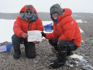
Plaza Argentina:  Base camp at 13,700.  One can get showers, a bed, a meal, send emails, see a doctor, buy stuff that you need, get beer and cigarettes if you are nuts....suffice it to say it is not a wilderness experience. We stayed here for three nights--doing one carry to camp one at 16,400, then moved up to camp one.  At camp one we stayed there for three night as well till we felt we had acclimatized well enough.  A word about altitude.  Acclimatizing has little to do with fitness--it just takes time.  Most people if dropped by a helicopter on top of Aconcagua without acclimatizing would be in serious trouble--even dead in a matter of minutes.   Pete and I spent 12 days on the mountain as compared with the 18days most expeditions spend on the mountain so we were really pushing the envelope with the altitude.  Both of us agreed that next time we would budget more days to acclimatize and for possible storm days.  As it turned out we were pretty lucky with the weather but could have very easily been shut down. 
100km wind over the summit.  Lots of stories of tents being shredded up high and nasty conditions. 

Lonely and somewhat grip camp 2 at 19,000.  Looking up the Polish Glacier.  The Polish Direct goes up the right side.  Conditions on the glacier were post holing in breakable crust.  We moved up to camp two on Dec 26th planning to climb the next day.  The weather report suggested that it would be the best day of the next few.  As it turned out the 27th was cloudy with light snow but with light wind.  I was not feeling %100 and visibility was poor so Pete and I opted to climb the easier Polish Traverse route--the bird in hand.  There had not been a good summit day in a while so there were quite a few groups chomping at the bit.  There were about 50 other people climbing on our summit day.  Did I mention this was not a wilderness experience?   It took us 10 hours to summit from our high camp and four hours to descend.  We saw a number people being assisted down--some who were barely conscious and having trouble walking.  Pete an I summited around 2:30 well within our turnaround window.  On the way down Pete an I were almost hit by falling rocks--four times.  Kind of scary to hear the shouting but not be able to see anything till rocks appeared out of the mist.  So we could understand one mishap but four times?  These were big rocks--basketball and beachball size.  Not cool. 


Summit:  22,841   A worthy adventure.  But nice to be back. 

OLA Community Service Opportunity


Gang, 

From our former fearless leader of the C-School Outdoor Program. We will keep you posted. - Travis  

I am working on the Board of the "Friends" of the Avie Center now, and these are some great opportunities for some of the leadership kids to help with a very related topic and local program. I will know more about the details of what help we will need by the end of the week. Also, if a school kid or teacher team wants to compete in the "skin2win" randonee race, let me know. All proceeds go to the avie center. More soon, but get the word out.....

tommy

1/12  Volunteer Meeting 5:30pm (probably at the Sun Valley Gun Club out Sun Valley Road, but will send details soon)
1/28  Skin It 2 Win It Randonee Race, Dollar Mountain, 10am - 3pm  (allow set-up/take down time)
 2/2   Banff Raffle Ticket Sales at Nordic Night, Downtown Ketchum, 5pm - ?
 2/3   Banff Raffle Ticket Sales at Banff Film Festival, NexStage Theatre, 5:45pm - 7pm and intermission, includes movie ticket
 2/4   Banff Raffle Ticket Sales at Banff Film Festival, NexStage Theatre, 5:45pm - 7pm and intermission, includes movie ticket

Sunday, January 8, 2012

Sagebrush Mountaineering

Rob, Pete and I ventured out to try our luck on Durrance this morning. For those that don't know, Durrance is the name of the most prominent triangular peak just north of the SNRA Headquarters on the right side of HWY 75. The weather when we left the car at 8:00am was overcast and 14˚. 


We climbed through the sagebrush and followed the typical skin track on the ascent and gained the south ridge, picking our way through the exposed limestone outcrops, tap-dancing on our skins asking them to do more than their fair share on the icy track. As we reached the first of three false summits, the wind began to blast (see clip).

 
Rob nearing the summit of Durrance. 

We tried to stay on the leeward (south) slope that provided a respite, but it was far too icy from the past week's freeze/thaw cycle. Upon topping out we determined that conditions didn't warrant trekking further out the ridge to shots that are usually worth walking to, peeled our skins and descended into Headquarters Canyon. 


We were more than pleasantly suprised as we took turns skiing the first northeast-facing shot into Headquarters. The top 6" of snow was wind affected but plenty soft enough to carve really fun turns on. As we returned below tree line we attempted to ski the shade lines on the north sides of the tree stands until we bottomed out in the gully above the SNRA. The last 1/4 mile down the canyon was crusty and impossible to ski so we took care to keep our knee tendons intact by carefully traversing and looking for the soft snow that the shade of a lone tree provided to make a jump turn here or there. We reached the road about 2.5 hrs after we left and all agreed that the effort was well worth the reward, granted our expectations were very low!